Chapter 09
How neighbourhoods form
A residential district is a record of the transport technology, the landholding pattern and the building economics of the decades in which it was laid out.
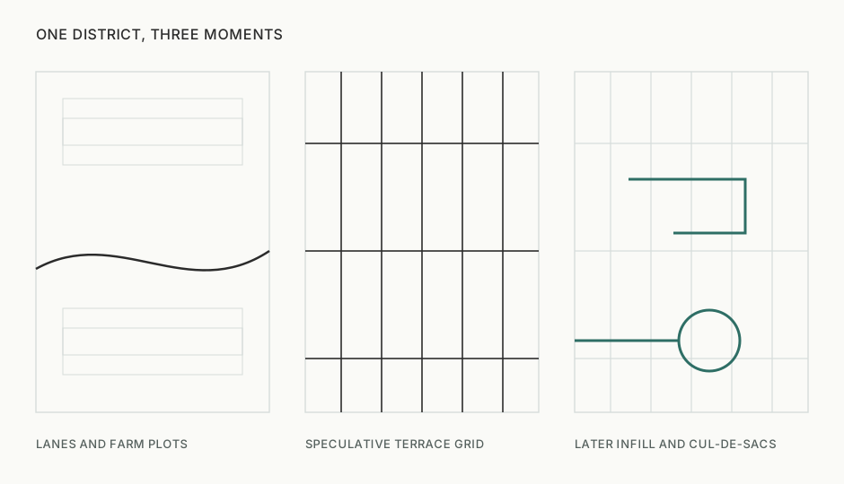
Neighbourhoods are not designed in the way that buildings are designed. They accumulate. Almost every residential district is the result of several rounds of development, each working on the land left by the last, and each governed by a different technology of movement and a different set of rules about what could be built. Reading a place means separating those rounds.
Transport sets the radius
The strongest single determinant of urban form is how far people could travel to work in an acceptable time. When that distance was a walk, settlement was dense, mixed and compact, because everything had to be within reach on foot. Housing sat close to workplaces, streets were narrow because they carried people rather than vehicles, and plots were small because land within the walkable radius was scarce.
Fixed-track transport changed the shape rather than simply the size. Trams and suburban railways extended the commutable distance but only along their lines, so growth moved outwards in fingers rather than as a disc, with dense development clustered near stops and open land left between the corridors. Much of what is now considered inner suburb was laid out in exactly this pattern, which is why such districts often have a high street running to a station and a grid of houses either side of it.
The private car filled in the gaps. It removed the requirement to be near a line at all, which allowed the land between the fingers to be developed, and it changed the geometry of streets: wider carriageways, curves, culs-de-sac, garages, and separation of housing from everything else. It also allowed shops to leave the high street for sites chosen by road access, which is why so many older local centres declined in a period when the population around them was growing.
Landholding sets the grain
The second determinant is who owned the land before it was built on, and in what parcels. Where a single large estate was developed at once, the result is regular: a consistent street pattern, uniform plot widths, one architectural vocabulary, sometimes a single name repeated across the streets. Where many small owners sold at different times, the result is irregular: streets that change width or direction at a former field boundary, terraces that stop abruptly, blocks of different periods pressed against one another.
Older lines survive this process with remarkable persistence. A field boundary becomes a garden wall; a farm track becomes an alley; a stream is culverted and reappears as a suspiciously curved road with no houses on one side. Once a boundary has been built along, it is extremely expensive to remove, so it outlives whatever produced it, often by centuries.
Building economics sets the type
The third determinant is the arithmetic facing whoever was building. Speculative housing has to be sold or let at a price the intended occupant can pay, which fixes the maximum that can be spent on land and construction per dwelling. Given a land price, that arithmetic dictates the density and therefore the type: how many dwellings per acre, hence terrace or semi-detached or detached, hence plot width, hence the rhythm of the street.
This is why housing types cluster so tightly by period and location. A builder working on expensive land near a station and a builder working on cheap land two miles out were solving the same equation with different inputs, and the answers are legible in the resulting streets. It is also why a single street can change character halfway along: the second half was built later, at a different land price, for a different market.
Rules arrive late and constrain what follows
Regulation entered the picture progressively. Public health and building acts standardised street widths, room heights, ventilation and drainage, which is why housing from certain decades is so consistent across entirely unrelated towns. Later, planning systems introduced the separation of uses, minimum standards for space and daylight, and controls on where development could occur at all.
Two effects of that last change are visible everywhere. Growth boundaries and protected landscapes redirected development to sites inside the existing built area or beyond the protected ring, producing both infill at higher density and satellite development further out. And conservation designation, listing and character policies froze the appearance of some districts while leaving others free to change, which over decades produced sharp contrasts between adjacent areas of identical original date.
Sorting, and its long shadow
Once built, districts sort. Households with more choice select on the attributes they can observe, chiefly schools, access and perceived safety, and their arrival changes those same attributes, which reinforces the initial signal. The process is slow, cumulative and self-confirming, and it operates over decades rather than years.
Institutional decisions leave the deepest marks. Where lending, insurance, covenants or allocation rules historically treated some districts differently from others, the resulting differences in maintenance, turnover and reinvestment persisted long after the rules themselves were abolished, because the building stock, the ownership pattern and the reputation all carried forward. Physical fabric outlives policy by generations, which is the recurring theme of the whole subject.
Reading it on the ground
All of this is legible on a walk. Changes of street width mark different rounds of development. A curved road among straight ones usually marks a watercourse or an old track. Consistent plot widths mean a single developer; varied ones mean many. A high street that stops abruptly marks the edge of a former settlement that has since been surrounded. Front garden depth records what the street was expected to carry. And a row of large houses subdivided into flats records a period in which their original market disappeared.
None of this requires a trip to the public records office. It only requires knowing that what is being looked at is a sequence rather than a design.